A little bit outside but really worth visiting!
Pydna, and the end of the Macedonian Kingdom
Most important
Pydna is located directly on the Aegean Sea, 16 km northeast of Katerini and 2.5 km south of the village Makrygialos.
Take a look around. The Axios Loudias National Park is on your left. Here you can watch birds and wild horses. Halfleft you see Greece's "second capital", Thessaloniki. Opposite is the Chalkidiki peninsula, more precisely the part called Kassandra.
History
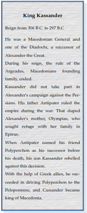
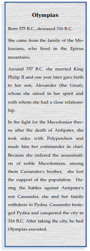
Pydna was first mentioned by the Greek historian Thucydides and gained importance during the Peloponnesian war. The Athenians besieged Pydna in 432 BC. King Archelaus I of Macedonia besieged the city around 410 BC from the land side, while the Athenian fleet took over the siege from the seaside. After Pydna was taken, Archelaus had moved the city 20 stadia (1 stadion = 600 feet (about 183 m)) further inland, in the area of today's Kitros. After Archelaus death, the inhabitants moved back to their previous location near the sea. 357 or 356 BC King Philip II, the father of Alexander the Great, conquered the city. 317 BC, Philips widow, Olympias, the mother of Alexander, was killed after the capture of Pydna by King Cassander.
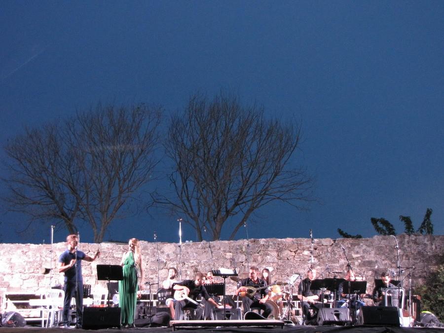
Concert at the Ancient Site of Pydna
Pydna first minted coins in the late 6th century BC. Further coins were discovered from the period between 389 and 379 BC.
Between the 6th and 7th century AD, Pydna was renamed Kitros. It was the most important city of Pieria until the 14th century.
In 1204 Franks took the city after a siege. They turned the Episcopal church into a castle and built a tower where their commanderinchief, Virich von Daum, resided.
In the 14th century, the inhabitants left the place and settled in today's Kitros.
The Battle of Pydna
After the Romans failed to defeat Macedonia in two wars, defeat came on June 22, 168 BC at the decisive fight near Pydna and Louloudies. It’s said that on the Macedonian side, also Thracian and Illyrian soldiers fought.
With around 40,000 men, both forces had roughly the same strength. King Perseus commanded the Macedonian units. The phalanx provided the bulk of the army. The cavalry and infantry were also involved in the battle.
The general Lucius Aemilius Paullus led the Roman army. Using the maniple tactic, the Romans fought with more agility and were more flexible. This tactic allowed the centurions to adapt the combat mode of their soldiers to the course of a battle. Weaknesses of the opponent were exploited immediately.
At the center of the Macedonian battle order stood the phalanx. Left and right of it fought the infantry, which in turn was flanked by the cavalry.
The Roman troop order was almost congruent with the Macedonian. Instead of the phalanx, however, stood the Maniple Phalanx with its flexible tactics. It was supported by war elephants.
At first, the Macedonians retained the upper hand. The Roman soldiers failed to avoid the long lances of the phalanx. Luck turned when the advancing Macedonian phalangites reached uneven, hilly terrain. The men were no longer able to keep their ranks closed. In the resulting gaps, the Romans pushed forward taking advantage of their maneuverability.
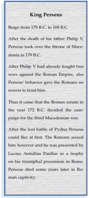
The battle ended with the victory of the Roman troops, whose losses were relatively small. About 20,000 Macedonian soldiers were killed. Thousands of the survivors were captured and enslaved. King Perseus was able to escape at first. However, the Romans seized him, and he was presented by Lucius Aemilius Paullus as a trophy on his triumphal procession in Rome. Perseus died a few years later in captivity. Lucius Aemilius Paullus was given the name “Macedonicus”.
Excavations
At the site of ancient Pydna, no intensive excavations have been carried out yet. The visible building remains date from the Byzantine era. The remnants of the city from the Classical, Hellenistic and possibly preGreek periods are partially buried under these ruins. The entire complex measures 320 by 130 m.
The earliest settlements from the Mycenaean period (circa 1400 BC) were found in the hills north of the excavation site. From 1000 till about 600 BC, the area was inhabited by Thracians. However, the settlement remains are no longer completely preserved, because the eastern part of the settlement has slipped into the sea.
The city wall was built in the 5th century BC. Sections of it are located 500 meters north of the archaeological site. The exact course of the wall is unknown yet. During excavation work parts of the wall were discovered occasionally. After taking the city, Philip II had the city wall destroyed. The Christianization of Pydna began in the 4th century. At this time, the first basilica was built. At the beginning of the 6th century, a second building was erected. The last built basilica was burnt down after an attack by the Bulgarians. At the end of the 10th century, a much larger basilica was built in its place. It measured 23.20 by 16.60 m. It was decorated with frescoes and the floor was covered with mosaics. As already mentioned, in 1204 Franconian knights altered the building into a fortress. They drilled a 22 m deep well and stored supplies. An example is an amphora where olive oil was stored in. Furthermore, they built a cistern. An underground passage allowed the garrison of the castle to escape to the outside in an emergency.
In the seafacing apse was a phryctoria, a device for exchanging signals with the opposite peninsula of Chalkidiki. With torches, light signals were transmitted over greater distances. So messages could be transmitted quickly over hundreds of kilometers.
Spolia (remains and fragments of columns, etc.) were worked into the wall surrounding the site. The oldest spolia is a Neolithic idol. The wall was built in two phases. In the 6th century AD, at the time of Justinian I, the first phase of construction took place. It was enlarged in the 10th century and some of the gates were closed. The wall is about 1.40 m thick and was reinforced by rectangular towers. Some remnants of the complex date from the 16th century, the period of occupation of Greece by the Ottomans.
West of the road that once connected Pydna with Dion, the remains of the city walls and a city gate can be seen. Today's course of the traffic route is largely identical to that of the antique road.
The Necropolises
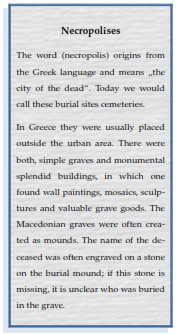
In the environment of ancient Pydna and on the road to Dion are some Macedonian tombs and the necropolises. According to ancient customs, the cemeteries were built along the roads and near the city gates. The oldest tombs are from the Bronze Age, the latest ones from the early Christian period. Minor tumuli (burial mounds) have been eroded over the centuries and are now no longer visible. Most of the works had to be carried out as rescue excavations. The finds, both in ancient Pydna and in the necropolises, show a shrinking population during the period of the second Greek colonization.
In the necropolises, the change of burying rites and the funeral customs over time can be observed. There were mostly earth burials, cremation of the deceased was rare. The dead were either burned directly in the grave or on wooden platforms. In some cases, the ashes were buried in copper kettles or clay pots. Toddlers were sometimes buried in common clay pots, which were broken for this purpose, and reassembled after embedding the body. In the 5th century BC, male corpses were buried with their head to the west, females with their head to the east. In the skulls of many of the deceased was the socalled Charon’s obol, which was put under the tongue of the dead, to pay the ferryman Charon for their transfer of the dead to Hades.
Grave Offerings
In addition to pottery, jewelry, weapons and tools, also richly decorated glass vessels came to light. The vessels were imported mainly from Attica, occasionally from Corinth or other places of the Aegean, some came from local production. Deceased children were often buried with clay figures. The jewelry is usually made of bronze, iron or silver, some are made of bone or gold. In the graves of deceased males weapons were found only in rare cases. Small vessels made of glass or alabaster, which were added to the corpses of women, are usually in good condition. Some of the finds are exhibited in the Archaeological Museum of Makrygialos, most of them in the Archaeological Museum of Thessaloniki.
Louloudies, once a Magnificent Bycantine Fortress
Most important:
The complex is 2.6 km northeast of the Macedonian tombs of Korinos and 5.8 km south of ancient Pydna. In the mid19th century, the French archaeologist Léon Heuzey identified the hills northwest of Louloudies as the place where in 168 BC the Battle of Pydna took place.
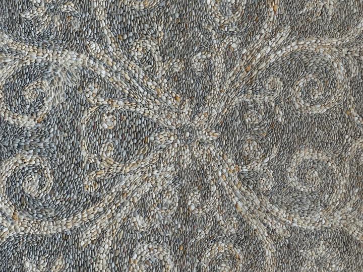
Example of a Pebble Mosaic
In the course of the reconstruction of the railway line Athens — Thessaloniki a fortified bishop seat from Byzantine time was excavated in the Louloudies area. The place was permanently populated since the Mycenaean period until the 7th century AD. It had the character of a village that served as a station between Thessaloniki and Larissa.
The Goths besieged Thessaloniki in 479 AD. In order to avert damage to the city, the magistrate agreed with the besiegers to place some other Macedonian cities under Gothic supervision. Among them were Pella, Pydna, Dion and Veria. Pydna (Kitros) was appointed bishopric, but the bishop resided in Louloudies.
The fortresslike complex was built in the last quarter of the 5th century. It is probably the same area that was called Anamon in Roman records. In the middle of the 6th century, the buildings were destroyed by an earthquake. The bishop left the place, which was later used as a cemetery. In the 7th century, Louloudies was finally abandoned after attacks by “barbarians”.
The Facility
The entire complex has a ground area of 80 by 90 m, it was surrounded by a wall. For its defense, four rectangular towers were built, which were at the corners of the bailey. A double gate on the west side was integrated into the wall. The outer gate was provided with a portcullis. On the threshold, one can still see the traces of vehicles that used to drive here. In the first construction phase, a threeaisled basilica (floor plan 35.50 by 19 m) and a residence for the bishop were built. Striking were the reception and the porticos of the building. The floors are decorated with mosaic. Mostly geometric figures are depicted, animal figures are rare. Remnants of a villa from the early 4th century BC under the palace were found. During the reign of Justinian I (527567 AD), the complex and the premises were expanded. Facilities for the production of wine and olive oil had been established and two warehouses had been built in the southwest corner. Another depot was near the west tower, outside the defensive walls.
Archaeologists discovered eight individual graves with a vaulted ceiling, partly the beautiful paintings have been preserved. In addition a larger number of simple graves were discovered, which date from the 3rd to 6th century AD.
The works took place from 1993 to 1997 and were led by the Byzantine Antiquities Authority in Thessaloniki. The railway line divides the excavation site diagonally. The remains of the western defense tower and a section of the wall are located outside the accessible area.
Numerous finds bring some light to the period between the 4th and the 7th century AD, an era in which little information is available for this part of Macedonia. They bear witness to the significance of the bishopric and give hints on the daily life and the existing technology of this time. After the place was finally abandoned by its inhabitants, the workshops ceased production. A sculpture workshop, remnants of a kiln for pottery and melting furnaces for glass products and for metal were found.
Most important
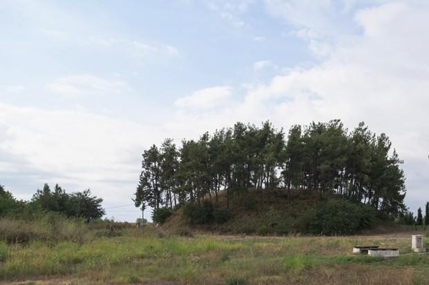
The burial mounds (tumuli) are located east (A) and west (B) of the Athens — Thessaloniki highway, about 600 meters northwest of the outskirts of the village of Korinos.
In December 2019 an event took place in Katerini where Dr. Thanassis Bindas demonstrated that it was the tomb of Olympias, mother of Alexander the Great. A confirmation from the responsible archaeologists is currently, as of 2020, pending.
Macedonian Tomb at Korinos, the Tumulus
The French archaeologist Léon Heuzey discovered grave A during his trip to Greece in 1855. The first description of the site was made in 1860. The excavations began a year later. Together with Honoré Domet Heuzey published his findings in 1876.
The archaeologist Matheos Besios reopened grave A in 1991. In the same year, he discovered grave B.
Both burial chambers had already been looted by robbers. These had removed the keystones of the vaults and thus gained access. It is unknown who was buried here, but the elaborate construction points to important people. Heuzey had moved almost all transportable artifacts (except for a stone block with the relief of a snake, two doors and smaller finds) to France. They are either exhibited or stored there in the Louvre, in Paris. The exact buildingdate of the grave vault was controversial. Recent findings point to the construction of tombs in the late 4th century BC and their use until the beginning of the 3rd century BC.
Excavations
Both tombs are clearly recognizable as burial mounds. They are overgrown with grass and pine trees. Both tombs are not located in the center of the tumulus, but left of the main axis (seen from the entrance), probably to deceive grave robbers. As it was customary in Macedonia at that time, the buildings were erected during the lifetime of the person(s) later to be buried in.
Grave A
It is located directly at the motorway service area at Korinos and is accessible from there. The hill has a diameter of 60 m and a height of 15 m. The total length of the tomb is 22 m. This is the largest Macedonian tomb ever discovered in Pieria so far. The outer entrance, which is over four meters long, was filled with mud, bricks or stones on both sides; the individual layers can be easily distinguished. The facade is only partially preserved and has been reconstructed. Heuzey had found it still intact. The tomb was once closed by a wall and behind it, by marble gates, these are modeled like wooden doors. There are imaginary fittings and nails to recognize. Both doors are still preserved. Recesses indicate that originally bronze rings were attached to it. The passage (dromos) leads to the first antechamber, it has a clear slope and diminishes in height. It is built of stone blocks that were once plastered. The ceiling is rounded (round barrel) and closed at its highest point with headstones. Colored remnants show that the plaster was once painted. The painting imitated a marble structure. The floor of the corridor consists of a pebble mosaic pavement.
The approximately 11 m long and 2 m wide Dromos opens into a forecourt (courtyard), which is decorated by a Doric entablature and a frieze with six Triglyphs. Remains of red paint are clearly visible. An opening leads from the courtyard into the 1.5 m long and 3 m wide antechamber of the tomb.
The 3 x 4 m burial chamber itself was protected by heavy gates and could be opened by a mechanical device. The forecourt, the antechamber and the burial chamber are covered by a common vault.
It is believed that a couple was buried here. A dog guarded the kline, which is probably assigned to the man, the second kline was protected by a snake. The chamber was plastered and painted, there are holders for grave offerings. Only the bones of the deceased, potsherds and an oil lamp were found. As inscriptions (from 1948 onwards) show, the grave was used at times by herdsmen to house their animals.
Grave B
The smaller grave B is located west of the highway and south of the motorway service area Korinos. It is accessible from a parallel street. The tumulus has a diameter of 40 m and is 13 m high. The tomb consists of a vaulted corridor, a 1.5 by 3 m measuring antechamber and the 3 by 3 m burial chamber. The antechamber was secured by a wall and a doublewinged gate. The gate was broken, restored and mounted again. It was carved out of limestone, was once plastered and is very heavy. The floors of the antechamber and the tomb are covered with flagstones, the walls are decorated with a meander.
In the burial chamber remains of a cremation and a body burial were discovered. Preserved are stone bases, on which presumably wooden couches rested. The chamber is painted with a circumferential frieze. As remaining grave goods two bronze coins, two leg protections, ceramics and fragments of other objects were found. On the walls and the ceiling mounts for other grave offerings are attached.
Most important
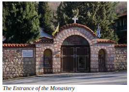
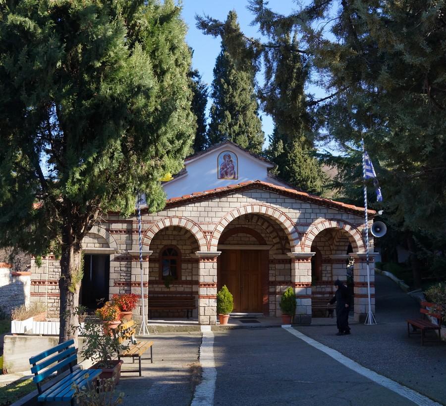
The monastery is dedicated to the Blessed Virgin and is located about 20 km northnorthwest of the city Katerini, about three km west of the village of Paleostani. Those who like to discover the gentle hilly landscape east of Mount Olympus will find the monastery a worthwhile destination.
History
The monastery was founded in the 10th or 11th century, but unfortunately no documents of that time are available. It was inhabited by monks and was under the patronage of the Patriarch of Constantinople. During the occupation of Greece by the Ottomans, the monastery was destroyed twice. Like other monasteries in the region, the monks offered the Greek freedom fighters support and shelter. The reprisals were terrible, and in 1821 the abbey was completely destroyed. It was rebuilt, but already in 1878, during the uprising on Olympus, the monastery suffered the same fate. Again it actively participated in the resistance against the oppressors and again it was destroyed for this. Only in 1993 it was repopulated by a sisterhood of nuns. The inhabitants of the surrounding villages helped with the construction, several donors generously contributed to the construction costs.
The Church
Embedded in almost untouched nature, the monastery appears at the end of a winding road. Two mosaics worth seeing are embedded in niches on the left and right of the gate. All the buildings within the complex are of recent date, only the fountain west of the parking lot dates back to times long past. The way into the monastery leads the visitor directly to the church. It was built of hewn stones, which are interrupted by decorative brick elements. At the gable you can see a picture of the Virgin Mary with Jesus on her lap. There is no bell tower, the church bell was placed outside the church. The wellkept flower beds leave no doubt that the monastery is inhabited by women. Next to the church is the administrative building. The nuns have their cells there. Guests are also welcomed here, a small area is used to sell all kinds of devotional objects. For selfsufficiency the inhabitants keep some chickens and have created a vegetable garden.
The church
It is a threeaisled construction with a vaulted central ceiling supported by round columns. Before entering the prayer room, one pass through a small narthex. At first one will notice the simply worked iconostasis, which reminds of a wall paneling with its embedded icons. Only the door to the apse is carved and painted.
The floor is covered with marble in which mosaics have been embedded. Some years ago the floor construction had to be renewed. The earth under the church had sunk. Above the central mosaic, which shows a double eagle, the church ceiling was painted with a picture of the pantocrator. The wall opposite the apse is decorated with a large painting. A very valuable icon of the Blessed Virgin hangs over a ledge, the front of which is decorated with a marble mosaic. Opposite the icon is the carved bishop's throne.
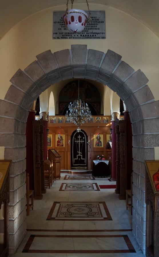
Interior of the Church Seen From the Narthex
The holy spring
Outside the monastery walls a path leads to an inconspicuous small building. Inside the cottage, a spring of holy water gushes out of a marble fountain, which is said to have healing properties. Once a man from Veria sought help for his mentally ill wife. They went to different doctors, but nobody could help her. One night the man dreamt that the water of a holy spring near the Panagia Makrirachi monastery would cure his wife. The monastery gave him permission to dig at the spot that appeared in his dream. In fact, he found a spring there whose water freed his wife from her illness.
Since then the holy water is said to have brought about several healings.
The Holy Spring
Most important
The monastery is located on a hill about three km south of Kolindros and about 21 km north of Katerini.
History
The date of the foundation of the monastery is unknown. The original documents were lost a long time ago. According to local residents, it has existed as a monastery, inhabited by monks, for centuries. During the Second World War, the last remaining cells of the old abbey were completely destroyed.
Only the church survived the fighting, but was in poor condition. In the early 1980s, Kolindros residents began building a new church to replace the previous one. In 1987 the rebuilding monastery was occupied by nuns who helped to rebuild it; construction works were completed in 1991.
The Church
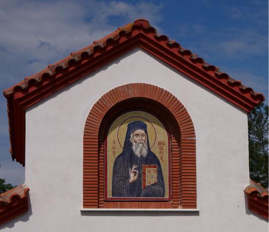
The visitor enters the complex through a gatehouse. Under the gable a picture of Saint Athanasios was painted. In the back of the house is a mosaic of the Saint Nectarios embedded in a niche. Notice how the artist depicts the vivid facial features and drapery of the robe.
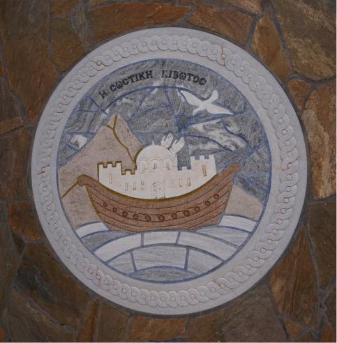
The rose bushes and decorative beds leave no doubt that the area is inhabited by women. The courtyard is laid out with stone slabs, partly decorated with terracotta elements. The path to the church is bordered by a meander, which is known as a braid or rope ornament. If you look closely, you will discover many artistic details. For example, Noah's ark with the inscription "Η ΣΩΣΤΙΚΗ ΚΙΒΩΤΟΣ" or the mosaic with two deer drinking from a stream.
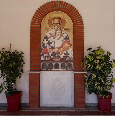
In front of the buildings, partly clad with natural stones, to the left and right of the path and in front of the church there are colonnades. Saint Athanasios is pictured next to a door. In the foreground you can see a faithful representation of the monastery church, which is protected by the saint.
If you want to linger a little, you will find inviting places to rest. Some offer a beautiful view of the surrounding hilly landscape.
Noah's Ark
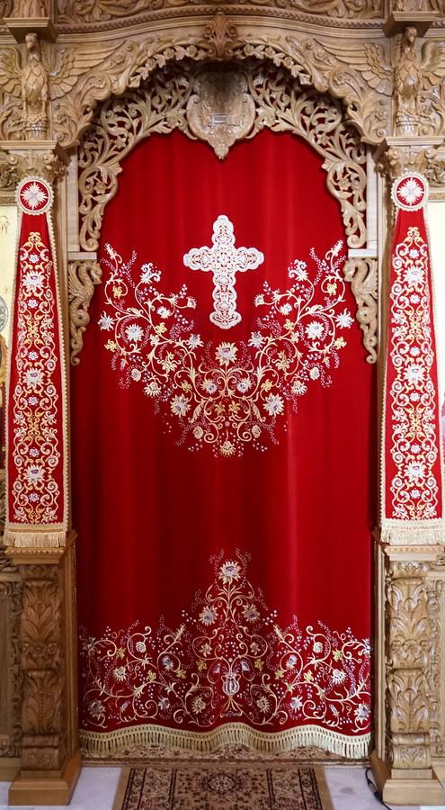
The nuns take care of a vegetable garden and create valuable handicrafts. A showpiece is the velvet curtain decorated with gold, silver threads and gemstones, which separates the prayer room of the church from the apse.
Protector of the Monastery
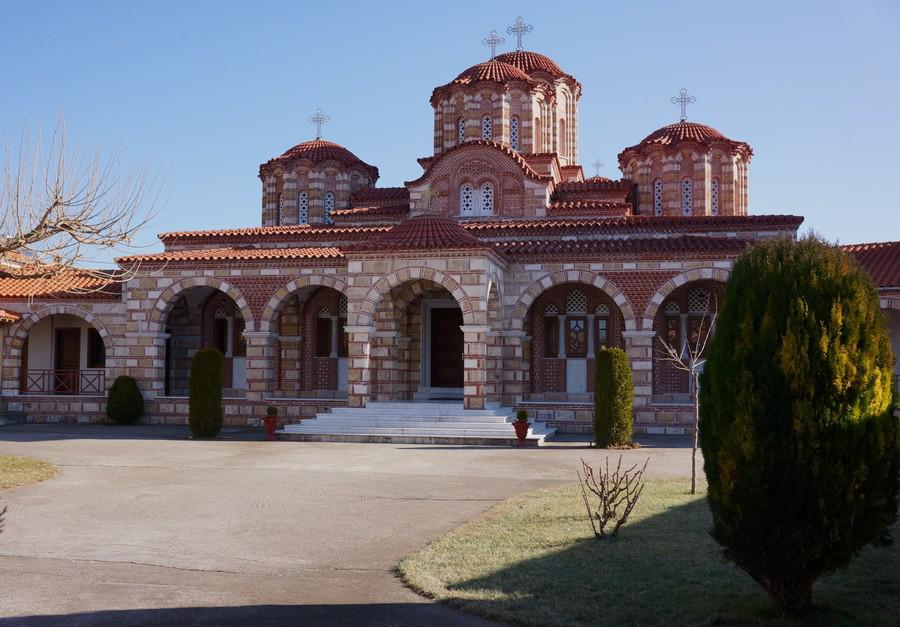
The construction corresponds to a threenave basilica with a spacious narthex. The building materials used are striking: worked stones in two different colours and bricks. The different coloured stones were cleverly combined. They were built up in alternation, and bricks were worked into the joints. Again and again bricks were also used as decorations in the facade. Mighty domes, crowned with crosses, are enthroned above the building.
The separate bell tower is build in the same style. The heavy church bells are attached to wooden beams with chains. Unlike the church, which is covered with roof tiles, the tower has a tin roof.
Inside, the church resembles that of Saint Dionysius in Litochoro in many details. One finds similar high desks with inlays, a huge chandelier decorated with images of saints and ostrich eggs, and bullet cases transformed into flower vases.
The Velvet Curtain
The floor was covered with marble, the roof construction rests on round columns. The carved iconostasis is magnificent and deserves closer inspection. You will discover masterfully carved figures of saints and animal figures such as eagles and dragons. The already above mentioned red velvet curtain hangs in the middle of the iconostasis.