O N E I D A C O U N T Y
T R A N S P O R T A T I O N & C O M M U N I C A T I O N
B Y J O S E P H P. B O T T I N I
I N T R O D U C T I O N : “ T H E G R E A T P A S S ”
❖
Pioneers, under the watchful gaze of
Oneida County, portioned off from Herkimer County in 1798, became the center of trade, earlier inhabitants, cross the Mohawk
transportation and communication owing to its geographical location and its topographical features.
River at the “ford” of the North-
The Appalachian Mountain Range running from Maine to Georgia was a hindrance to South/East-West trails.
transportation inland. With this impediment to expansion settlers were confined to the coastal region. One natural break in the mountain range with a semi-level, navigable river provided the only feasible access. Thus, the Mohawk Valley with the Mohawk River opened development. Oneida County, sitting in the middle of this valley, prospered and grew in importance through transportation (western lands) and communication (news carried by settlers and early newspapers).
The American Indians, mid 1400s, were the first to use this “Great Pass” through the Appalachian Mountains. The “ford” of the Mohawk River was provided at this location by its meandering path slowing the current, fed by two creeks—Reals Creek to the north and Ballou Creek to the south) that C h a p t e r 1 ✦ 7
XXON Chapter 1_Layout 1 1/23/2015 11:46 AM Page 8
❖
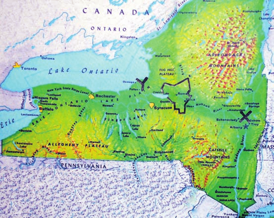
Right: A map displaying the central
location of Oneida County.
Below: X-Y is the path of the Mohawk
Valley to the interior of the continent
through the only level navigable water
route in the mountain range from
Maine to Georgia.
8 ✦ O N E I D A C O U N T Y : A n I l l u s t r a t e d H i s t o r y
XXON Chapter 1_Layout 1 1/23/2015 11:46 AM Page 9
deposited silt lowering the riverbed and
O N E I D A C O U N T Y
reducing the height of the banks. At this
T R A N S P O R T A T I O N
location, with the juxtaposition of divine,
geographic gifts providing the “ford,” the
Transportation began with the river system.
community of Old Fort Schuyler (Utica) began
Traders and settlers came north up the Hudson
in Oneida County.
River and west (at Albany) onto the Mohawk River.
Following the arrival of the Dutch and then
They then traveled westerly on the Mohawk River
the English (1500s-1600s), the fur trade
to Fort Stanwix (Rome). Here the Mohawk River
became a viable industry. This “furs-for-
curves northward to its source in the hills north of
trinkets-and-guns” trade between the pioneers
Rome. This created a “Carrying Place” (De-O-
and the Iroquois developed into a thriving
Wain-Sta in Iroquois) where travelers had to
business in early Oneida County. This trade
unload their boats and carry them west for
opportunity was added to pioneer travel,
approximately one mile to westerly flowing Wood
military transportation, communication, and
Creek. They then reloaded their boats to continue
land development.
the journey to Oneida Lake. From Oneida Lake
The importance of this opening in the
they traveled on the Oneida River to the Oswego
mountains was first understood by General
River to Lake Erie and beyond.
George Washington on his nineteen-day tour
The “Carrying Business” of moving goods
(post Revolutionary War) through the Mohawk
and passengers from the Mohawk River to Wood
Valley to see where the war played-out its part.
Creek became the occupation of those living
He was impressed with its possibility as an
near Fort Stanwix (Rome). Owing to its features
approach to the uncharted and uninhabited
of waterways and “The Great Carry,” commerce
interior of the continent. He envisioned the
preceded farming and settlement in Oneida
improvement of internal communication of the
County along the Mohawk Valley.
nation through the Mohawk Valley.
The few farm settlements and people in
Overwhelmed with his findings, Washington
the “carrying trade” abandoned the area at
said:
the approach of the Revolutionary War.
This transportation route became solely a
Prompted by these actual observations I
military transport of troops and supplies to
could not help taking a more…extensive view of
western outposts.
the vast inland navigation of these United States
Following the Revolution, a trickle of
…Would to God we may have wisdom enough
immigrants from New England became a stream
to improve them….
of pioneers into Oneida County. This influx of
❖
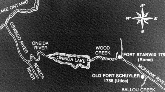
The Mohawk Valley water route to the
interior of the continent began with
the Mohawk River. It traveled west to
Rome, to the “Carry” (Deowainsta in
Iroquois) approximately one mile to
Wood Creek, onto Oneida Lake, to
Oneida River, to the Oswego River,
onto Lake Ontario of the Great Lakes.
C h a p t e r 1 ✦ 9
XXON Chapter 1_Layout 1 1/23/2015 11:46 AM Page 10
and a stage route between Albany and
Whitestown the next year.
One of the first to be built was the Seneca
Turnpike (Route 5) that extended from the ford
(at Utica) to the frontier of western New York.
Another turnpike was begun, the Great Western
Turnpike (Route 20), across the southern portion
of Oneida County. Although seasonal roads at
best, they did provide a beginning for the vast
network of roads that crisscross the County
today. The state legislature provided for the
incorporation of private companies to construct
and improve plank roads in 1847 to help farmers
get produce to market. Close to a dozen plank-
road companies formed in Oneida County.
The Seneca Turnpike was the better road
because it was more level, and prudent for
❖
settlers to central Mohawk Valley brought a huge
heavy loads, than the Great Western Turnpike
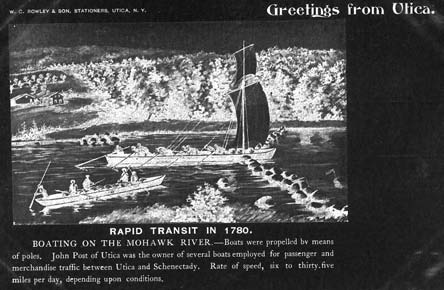
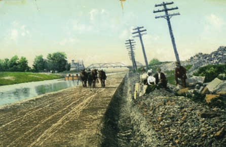
Above: Early river transportation
increase of traffic on the waterway. An initial step
with its frequent undulating hills. Because of
necessitated “polling” the bateaux up-
to close the “carry” from Mohawk River to Wood
water level inconsistency and inaccessibility
river requiring physical strength and
Creek (1797) was a two-mile canal of The
during the winter months, turnpikes became
mental perseverance.
Western Inland Navigation Company.” During
more popular than water travel. Between 1847
the1790s the company constructed many short
and 1854, about twenty plank roads were built
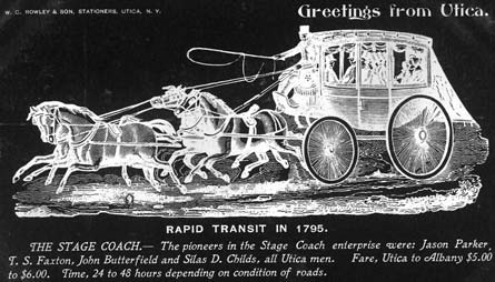
Below: The early stagecoach (rapid
canals throughout Oneida County so small boats
in Oneida County. Due to the cost of
transit of 1795) connected
could bypass rougher waters.
replacement and competition from railroads,
communities with a crude mode of
Boats were a slow, inconvenient way of travel.
most plank roads were abandoned by the late
passenger and mail routes requiring
With the size restrictions of boats (Bateaux) the
1870s. Bicyclists and then automobile owners
skilled drivers and hardy passengers.
freight capacity was limited. The laborious method
first agigated for better roads. By 1952 over
of “pike polling” the boats up-river became a job
thirteen hundred miles of improved roads
for physically strong and mentally tough men.
comprised the road system in Oneida County.
At the same time (1798-1800), a company
During the War of 1812, Oneida County held
was engaged to construct a few crude roads—
the major transportation routes. Both the Seneca
carved out of the wilderness—that ushered in
and Great Western Turnpikes were used to
the turnpike era. Early roads included the
transport supplies to military outposts in the
opening to the Genesee Country in 1790, a mail
western part of the state while the Mohawk
route between Albany and Whitestown in 1792
River-Wood Creek waterway was used to send
supplies to Sackets Harbor.
The Erie Canal was born out of a need for
better water transportation. Neither natural
waterways nor land transportation proved
adequate. It was inexpensive by water, but rivers
were not dependable. Land transportation was
more dependable, but very costly. Both land
and water deficiencies provided reasons to
support George Washington’s vision for a man-
made waterway through the Mohawk Valley.
The stage was set for the long-debated canal
transportation system. Thomas Jefferson
doubting the wisdom of such a huge canal
project said, “Making a canal 350 miles through
the wilderness is a little short of madness.”
1 0 ✦ O N E I D A C O U N T Y : A n I l l u s t r a t e d H i s t o r y
XXON Chapter 1_Layout 1 1/23/2015 11:47 AM Page 11
❖
Left: The early success of small canals
connecting natural bodies of water
fostered the notion of a cross-state
canal. Not accepted by all folks, this
363-mile “ditch” containing over 30
locks became the catalyst for early
trade and pioneer travel. This far out-
performed the coach or natural
waterways and brought a boom to
any community on its path.
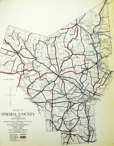
Below: This map from 1913 displays
the result of efforts made by an Oneida
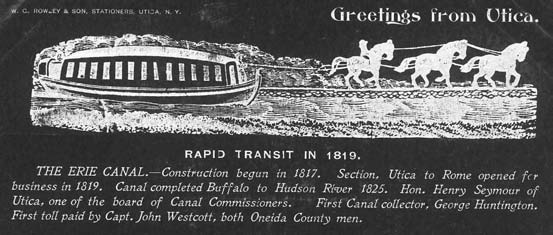
The first leg of a 363-mile “ditch” from
From 1825 to 1845, New York State
County Automobile Association to
Albany to Lake Erie was begun in Rome in 1817
witnessed a canal building boom. No less than
encourage funding of road development
and reached completion at Utica in 1819. Flat-
ten sections of canals and three complete canals
and improvements. In fifteen years,
bottomed boats (Durham) carrying heavier
were constructed in Oneida County. Although
Oneida County went from impassable
cargoes (75 tons) in shallow water passing
useful for a short time in the growth of Oneida
dirt paths to a “groomed” road matrix.
directly through the valley enhanced the
growth of Oneida County, home of the first
completed section. By the total completion
of the Erie Canal across the State in 1825,
Oneida County had a five-year head start over
the other counties.
Until the completion of the Erie Canal at
$19,679 per mile, transportation was slow and
laborious. The Erie Canal created an
opportunity for more complete travel from the
east coast to the interior of the continent. This
man-made “river” allowed increased load from 2
to 6 tons, reduced the cost of freight from $95-
$125/ton to $4-$6/ton, and shortened the
journey from 4-6 weeks to 6 days, for cross-
state travel.
It was enlarged just five years after its
completion. At a cost of $96.7 million dollars, it
was enlarged again and the route altered to its
present location in 1918, accompanied with a
name change to Barge Canal System (recently
renamed back to Erie Canal).
Today, the Erie Canal is the cross-state, east-
west route of the New York State Canal System.
In 2000 the United States Congress designated
the Erie Canalway a “National Heritage
Corridor.” This distinction recognized the
national significance of the canal as the most
successful human-built waterway work of civil
engineering construction in North America. At
that time The Erie Canal was referred to as the
“Eighth Wonder of the World.”
C h a p t e r 1 ✦ 1 1
XXON Chapter 1_Layout 1 1/23/2015 11:47 AM Page 12
❖
County’s textile industry, neither the 97- mile
Above: At 4 feet deep and 40 feet
Chenango Canal (abandoned in 1870s), or the
wide this placid body of water
78-mile Black River Canal (until 1924
became the “rapid transit” of its day,
connecting Boonville with Rome) resulted in a
decreasing travel time considerably.
great impact.
It is prudent to note that early canal
entered Oneida County, the Syracuse and Utica
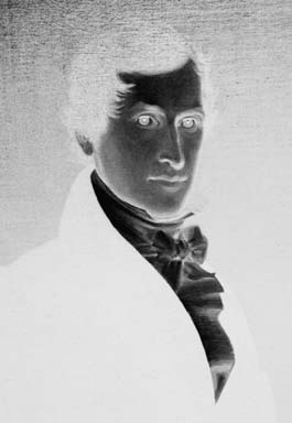
Top, right: The son of Whitestown
“engineers” began their work with little or no
(through Rome). Utica and Rome, Oneida
founder Hugh White, became Chief
prior training. Civil engineering was yet
County’s two largest urban centers, competed
Engineer Wright’s primary assistant.
unheard of and when named Chief Engineer of
for railroad supremacy between 1836-1840.
the Erie Canal project, Benjamin Wright of
By 1850, seven railroads originated in—or
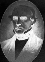
Below: Beginning his career as a coach
Rome had minimal experience. Wright went on
ran through—Oneida County including the
driver, Butterfield became a
to achieve national prominence and noted as the
Utica-Black River Railroad. With other smaller
transportation entrepreneur with
Father of American Civil Engineering. Canvass
lines they were consolidated into the New York
passenger and freight companies. In
White, son of Whitestown founder Hugh White,
Central in 1853. In 1869 the New York Central
1859, he took the government’s
ably assisted Benjamin Wright.
absorbed the Hudson Central Railroad. In 1891,
challenge to establish a transportation
Working as a laborer, rising to an engineer’s
the New York Central further consolidated other
system for freight and passengers from
position, John B. Jervis of Rome became known
smaller railroads—such as the Clayton and
the Mississippi River to the west coast.
for promoting much advancement in
Ogdensburg lines. An agreement between the
At $600,000, it was the largest
transportation. He earned the reputation as the
New York Central, the Delaware-Lackawana-
contract let by the federal government.
leading American engineer of pre-Civil War era.
Western, and the New York, Ontario-Western
Two other Oneida County men played major
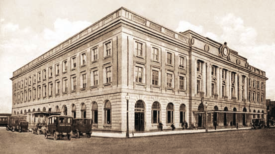
railroads for use of the facilities in Utica gave the
roles in the development of transportation and
complex a name—“Union” Station; a jewel in
earned national reputations. John Butterfield
the crown of many historically significant
created the American Express Company (1850)
Oneida County places with a direct connection
and the Overland Mail Company (1858)—the
to the development of America.
first transcontinental stagecoach.
Union Station, an influential force linking a
Squire Whipple, forever linked with bridge
glorious past with present-day transportation in
building and the iron truss, became known as
Oneida County, remains following a successful
the Father of American Bridge Building.
effort by the Landmarks Society to save it from
During this canal period, another
the wrecking ball in 1978. The Adirondack
transportation system—the railroad—was
Scenic Railroad continues to transport tourists
emerging. The first railroad to add to the
to the North Country as it did in transporting
commotion was the Utica-Schenectady Railroad
many wealthy folks to their Adirondack “Great
in 1836. Three years later, a second railroad
Camps” during the 19th century. With better
1 2 ✦ O N E I D A C O U N T Y : A n I l l u s t r a t e d H i s t o r y
XXON Chapter 1_Layout 1 1/23/2015 11:47 AM Page 13
highways and improved motor vehicles, the
railroad business was infringed upon during
post World War II. Many bankrupt railroads
combined including: Pennsylvania with New
York Central (Penn-Central) as well as the Erie
with the Delaware, Lackawana and Western
(Erie-Lackawana). The Penn Central and Erie-
Lackawana then combined with other bankrupt
railroads becoming Conrail in 1976.
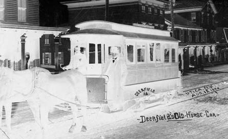
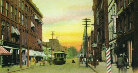
In the 1860s (horse car) trolley lines were
evident in Oneida County. Many inter-urban
and intra-urban trolley lines were constructed
between 1826 and 1886.
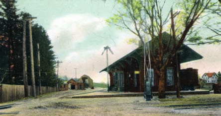
❖
Top: One of many small community
train depots that dotted the landscape
in the later 1800s. It became (and still
is) a “Community Building” used for
meeting purposes.
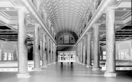
Middle: Now named The Boehlert
Center, Union Station was built in
1914 as the intended headquarters of
the New York Central Railroad. Never
achieving this goal, it was named
Union Station when it became the
depot for many smaller lines and
consolidated railroad companies.
Following a restoration project to save
it from the wrecking ball in 1978, it
remains a jewel in the crown of the
Bagg’s Square Corridor in Utica.
Today, it serves residents as a train
and bus center as well as housing
Oneida County offices on the second
floor and the Oneida County Motor
Vehicle Bureau in the southwest
section of the magnificent lobby.
Bottom: A view of the stately marble
columns in the main lobby of Oneida
County’s largest railroad depot. The
county’s central location was once
considered a prime site for the
headquarters of the New York Central
Railroad Company.
C h a p t e r 1 ✦ 1 3
XXON Chapter 1_Layout 1 1/23/2015 11:48 AM Page 14
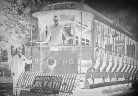
the 1890s. The electric trolley changed people’s
lifestyle. Living close to employment in crowded
neighborhoods was no longer necessary.
Pleasure time activities were made available
with the building of amusement parks at the
end of trolley lines.
In 1910, Car 502 took 21 local entrepreneurs
and others on a 2,000-mile promotional/fact-
finding journey through 6 states. Both urban and
inter-urban transportation served the public until
1933 when the inter-urban trolley gave way to
buses. With aid of the federal Civil Works
Administration (1933) trolley track removal
began. A 21-gun salute was given the last trolley
run on the Whitesboro line in 1938. By May 12,
1941, the last trolley left the transportation scene.
Immediately, the new autobus and personal
automobiles displaced the trolley system. For a
number of years the horse and buggies, trolleys,
bicycles and new-fangled automobiles grudgingly
shared space on the roadways.
Bicycling, a new craze took center stage in
Oneida County in the late 1800s. Although used
as a means of transportation—doctors making
house calls, mayors and judges pedaling to
government halls and society ladies making
social visits in 1893—it was more a hobby.
Good highways became a concern as early
as 1902, when the Utica Automobile Club
and many bicycle clubs petitioned for better
roads. The Automobile Club of Utica, and eight
other automobile clubs, met in Chicago to
initiate the Automobile Association of America.
New York State regulated “automobiling” in
1907 with the first motor vehicle law instituting
speed limits of 20 miles an hour in the country,
15 miles in communities and 10 miles in heavily
populated areas.
Early 1900 automobile companies in Oneida
County included: W. H. Birdsall and A. Vedder
Brower Company (Buckmobile); Remington
Automobile and Motor Company, (Remington);
Utica Carriage Company (formerly Willoughby
of Rome), manufactured frame bodies for
Packard, Cadillac, Rolls Royce, and Lincoln; and
Charles Mott’s Wheel Works producing
automobile tires and axles.
In the 1950s, with the need for good
Oneida County became one of only five
highway transportation between states, in
locations (Boston, New York, Philadelphia and