6-1. General
a. All of these data are not required to use the a. The manual data management system de-system effectively. New types of data can be
scribed in chapter 5 is a systematic way of record-incrementally added. The system’s programs rely
ing and storing information needed for effective
primarily on distress analysis for ranking, budget-road maintenance management. However, for
ing, and forecasting. These data are collected by
medium- to large-sized installations, the number of trained inspection teams on a sampling basis.
record cards can increase to the point where it is b. Micro PAVER is designed to run on IBM or time-consuming to manually search, sort, and com-IBM-compatible equipment (MS-DOS), with a mini-
pile information for various maintenance manage-
mum of 640-k RAM and a 20-Meg hard drive.
ment applications. An optional computerized sys-
6-4. System use and update
tem is available to automatically retrieve, sort,
and compile data. In addition, the computer may
Micro PAVER should be used and updated in a
be used to make a number of calculations that
way similar to the manual system. Some of the
would have to be done manually.
computer reports can be used as an aid in schedul-
b. The unsurfaced roads management system is ing work for the road maintenance crew or to
a component of the Micro PAVER pavement man-
generate work to be done by contract. Other
agement system. This chapter briefly describes the reports can be used to communicate road condition
computerized Micro PAVER system. Specific user
and maintenance requirements to higher manage-
instructions may be obtained from the assigned
ment. Micro PAVER will automatically delete the
responsible agency-the U.S. Army Center for
corresponding project from the road work plan and
Public Works.
will store the work in completed projects as work
history, thereby capturing the history of the dis-
6-2. Use of computerized Micro PAVER
tresses, repairs, quantities, and associated cost.
Generally, the computerized system is recom-
a. Unsurfaced road inspection information. As mended for expedient data handling and report
road sections are inspected, information should be generation. It may become advantageous to use it
input to Micro PAVER; Micro PAVER will not
for road networks with a large number of road
delete the results from any previous inspection of sections (more than 200). However, if the choice of the section unless specifically required to do so by system is not clear-cut, it is always possible to
the user. Therefore, road condition information
implement a manual system and then later con-
showing a condition profile over a period of time
vert to a computerized system.
will be readily available. Micro PAVER is fully
described in TM 5-623.
6-3. System description
b. Work requirements. For those sections where The system consists of a computerized data base
existing maintenance policy is to continue (usually and a number of programs that store, retrieve, and the majority of sections in a road network), work
manipulate the data, as well as do a variety of
requirements can be automatically developed by
analyses and calculations required for network
Micro PAVER based on user maintenance policy
and project management decisions. The data base
and distress results of road inspections.
will store properties of each section of road as well c. Incorporation of improvements. It should be as numerous other types of data on secondary
noted that Micro PAVER has been designed so
structures, traffic, maintenance history, etc. In
new technological procedures and improvements
addition, the system stores detailed cost records
can be incorporated into it as they become
and the local maintenance policy.
available.
6-1
TM 5-626
APPENDIX A
REFERENCES AND BIBLIOGRAPHY
A-1. References
Department of the Army publications
AR 420-72
Surfaced Areas, Bridges, Railroad Track and Associated Appurtenances
TM 5-623
Pavement Maintenance Management
TM 5-624
Maintenance and Repair of Surface Areas
TM 5-822-2
General Provisions and Geometric Design for Roads, Streets, Walks, and Open Storage Areas
Department of the Army forms
DA Form 7348-R
Unsurfaced Road Inspection Sheet (Prescribed in para 3-3.)
DA Form 5149-R
Branch Identification Summary
DA Form 5149-1-R
Branch Identification Summary-Continuation Sheet
DA Form 5155-R
Branch Maintenance and Repair Requirements
A-2. Bibliography
Ashcraft, J., Maintenance Procedure Guide for Unsurfaced Roads, Cold Regions Research and Engineering Laboratory, U.S. Army Corps of Engineers, Hanover, New Hampshire, Contract Training Manual (February 1991).
Charmichel, R. Frank III, et al. Measurements for Determining Low Volume Road Maintenance Needs, Pan American Highway Maintenance Conference, Los Angeles, Transportation Information Exchange, St.
Michael’s College, Winooski, Vermont (September 1985).
Class 4 and Development Roads: A Guide for Vermont Towns, Fact Sheet T-105, Transportation Information Exchange, Vermont Local Roads Program, St. Michael’s College, Winooski, Vermont.
Eaton, Robert A., et al. Rating Unsurfaced Roads, A Field Manual for Measuring Maintenance Problems, Cold Regions Research and Engineering Laboratory, U.S. Army Corps of Engineers, Hanover, New Hampshire, Special Report 87-15 (August 1987, revised September 1988).
Effects of Drainage Design on Road Performance, Fact Sheet T-610, Transportation Information Exchange, Vermont Local Roads Program, St. Michael’s College, Winooski, Vermont.
Maintaining Gravel Road Surfaces, Fact Sheet T-225, Transportation Information Exchange, Vermont Local Roads Program, St. Michael’s College, Winooski, Vermont.
Maintaining the Vermont Backroad, Fact Sheet T-205, Transportation Information Exchange, Vermont Local Roads Program, St. Michael’s College, Winooski, Vermont.
Pavement Surface Evaluation and Rating PASER Manual, Transportation Information Center, University of Wisconsin, Madison (November 1987).
Riverson, John, et al. Unpaved Roads Maintenance Management, A Guide for Counties, Cities and Towns in Indiana, Publication No. H-87-3, Purdue University (March, 1987).
Road Dust Control With Calcium Chloride, Fact Sheet T-220, Transportation Information Exchange, Vermont Local Roads Program, St. Michael’s College, Winooski, Vermont.
Stevens, Louis B., et al. Road Surface Management for Local Governments: Resource Notebook, DOT-85-37, Federal Highway Administration, Washington (May 1985).
Strombom, Robert D., Maintenance of Aggregate and Earth Roads, FHWA-TS-90-035, Washington State Department of Transportation, McLean, Virginia (June, 1987).
A - l
TM 5-626
APPENDIX B
DISTRESS DESCRIPTIONS
B-1. Introduction
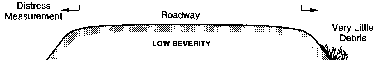
(a) Ponding water or evidence of ponding
The seven distress types and severity levels for
water in the ditches.
unsurfaced roads are discussed below and are
(b) Overgrowth or debris in the ditches.
shown in figures B-1 through B-14.
(2) At security level M, moderate amounts of
the following exist:
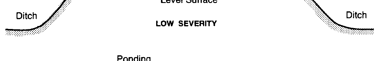
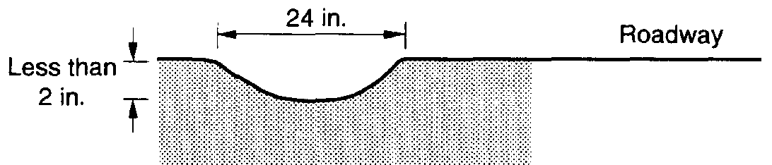
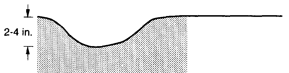
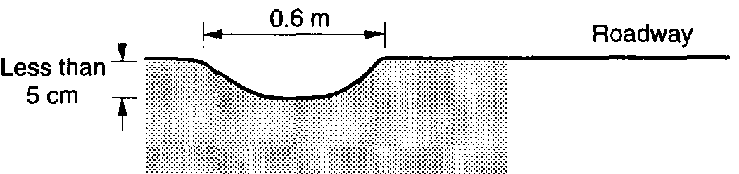
B-2. Distress 81 -Improper cross section
(a) Ponding water or evidence of ponding
a. Description. An unsurfaced road should have water on the road surface.
a crown with enough slope from the centerline to
(b) Overgrowth or debris in the ditches.
the shoulder to drain all water from the road’s
(c) Erosion of the ditches into the shoulders surface. No crown is used on curves, because they
or roadway.
are usually banked. The cross section is improper
(3) At security level H, large amounts of the
when the road surface is not shaped or maintained
following exist:
to carry water to the ditches.
(a) Ponding water or evidence of ponding
b. Severity levels.
water in the ditches.
(1) At security level L-
(b) Water running across or down the road.
(a) Small amounts of ponding water or evi-
(c) Overgrowth or debris in the ditches.
dence of ponding water on the road surface.
(d) Erosion of the ditches into the shoulders (b) The road surface is completely flat (no or roadway.
cross-slope).
c. How to measure. Drainage problems are mea-
(2) At security level M-
sured in linear feet (linear meters) per section
(a) Moderate amounts of ponding water or
parallel to the centerline. The maximum length is
evidence of ponding water on the road surface.
two times the length of the sample unit (two
(b) The road surface is bowl-shaped.
ditches for the total length of the sample unit). For (3) At security level H-example, a sample unit may have 120 feet (36
(a) Large amounts of ponding water or evimeters) with low severity and 35 feet (10.5 meters) dence of ponding water on the road surface.
with high severity.
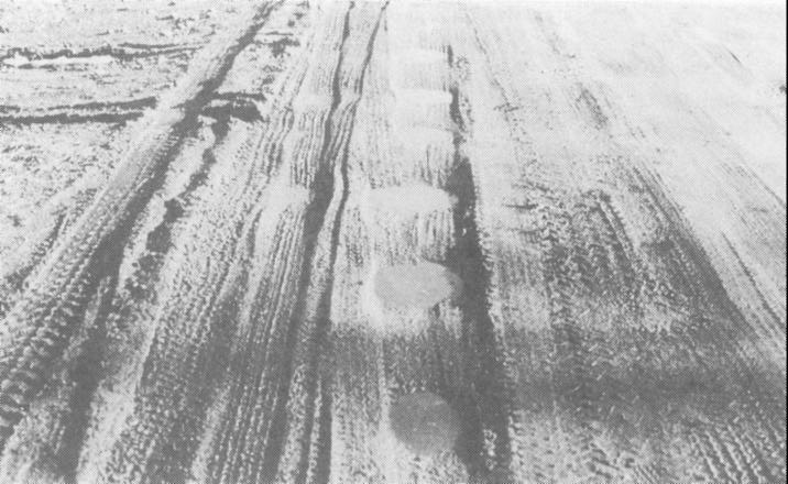
(b) The road surface contains severe depres-B-4. Distress 83-Corrugations
sions.
c. How to measure. Improper cross section is a. Description. Corrugations (also known as measured in linear feet (linear meters) per sample washboarding) are closely spaced ridges and val-unit (along the centerline or parallel to the center-leys (ripples) at fairly regular intervals. The ridges line). The cross section runs from the outside
are perpendicular to the traffic direction. This type shoulder break on one side of the road to the
of distress is usually caused by traffic and loose outside shoulder break on the other side. Different aggregate. These ridges usually form on hills, on
severity levels may exist within the sample unit.
curves, in areas of acceleration or deceleration, or For example, there could be 60 feet (18 meters)
in areas where the road is soft or potholed.
with medium severity and 40 feet (12 meters) with
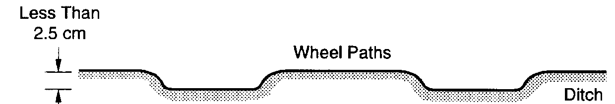
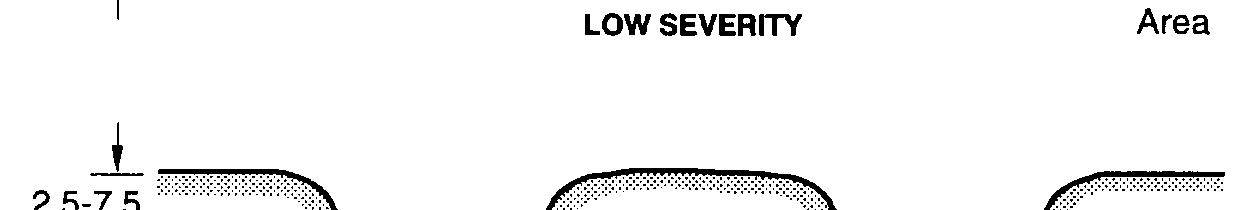
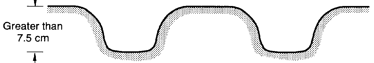
b. Severity levels.
low severity. The maximum length would be equal
(1) At security level L, corrugations are less
to the length of the sample unit.
than 1 inch (2.5 centimeters) deep.
(2) At security level M, corrugations are be-
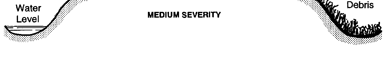
B-3. Distress 82-Inadequate roadside drain-
tween 1 and 3 inches (2.5 and 7.5 centimeters)
age
deep.
a. Description. Poor drainage causes water to (3) At security level H, corrugations are
pond. Drainage becomes a problem when ditches
deeper than 3 inches (7.5 centimeters).
and culverts are not in good enough condition to
c. How to measure. Corrugations are measured direct and carry runoff water because of improper
in square feet (square meters) of surface area per shape or maintenance.
sample unit. The amount cannot exceed the total
b. Severity levels.
area of the sample unit. For example, a sample
(1) At security level L, small amounts of the
unit may have 230 square feet (21 square meters)
following exist:
with moderate severity and 50 square feet (4.6
square meters) with high severity.
B - l


TM 5-626
Figure B-1. Improper cross section (English or metric units).
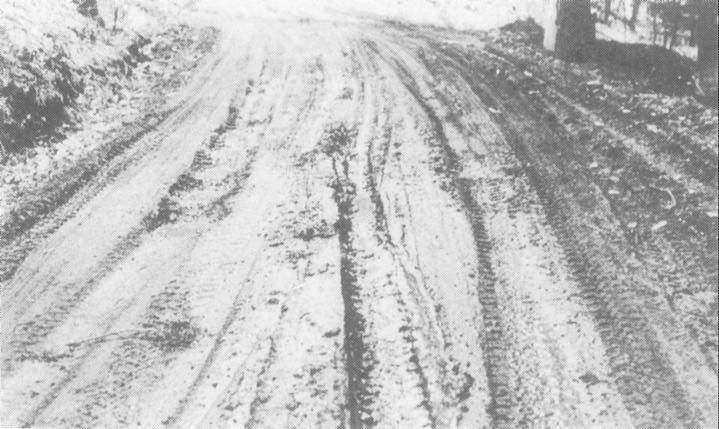
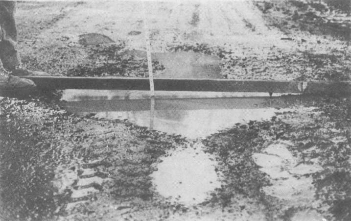
Figure B-2. High severity example of improper cross section.
B-2


TM 5-626
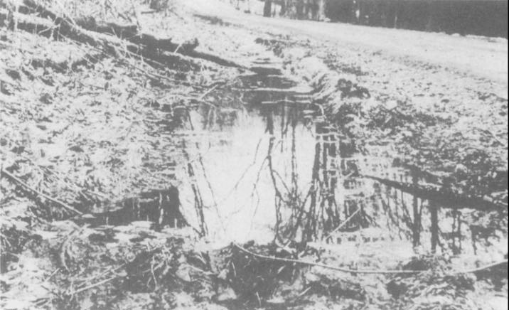
Figure B-3. Inadequate roadside drainage severity levels (English or metric units).
Figure B-4. High severity example of inadequate roadside drainage.
B-3
TM 5-626
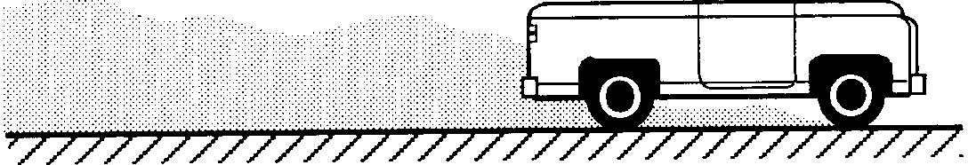
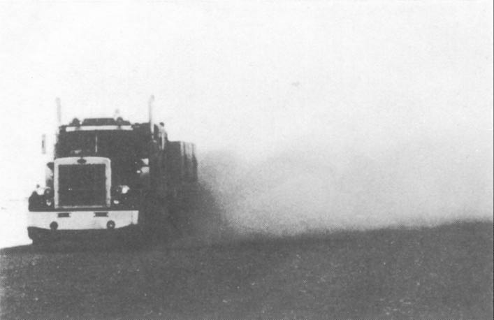
B-5. Distress 84-Dust
c. How to measure. Drive a vehicle at 25 miles a. Description. The wear and tear of traffic on per hour (40 kilometers per hour) and watch the
unsurfaced roads will eventually loosen the larger dust cloud. Dust is measured as low, medium, or
particles from the soil binder. As traffic passes, high severity for the sample unit.
dust clouds create a danger to trailing or passing B-6. Distress 85-Potholes
vehicles and cause significant environmental prob-
lems.
a. Description. Potholes are bowl-shaped depres-b. Severity levels.
sions in the road surface. They are usually less
(1) At security level L, normal traffic produces
than 3 feet (1 meter) in diameter. Potholes are
a thin dust that does not obstruct visibility.
produced when traffic wears away small pieces of
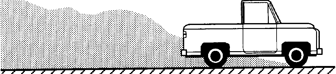
(2) At security level M, normal traffic pro-
the road surface. They grow faster when water
duces a moderately thick cloud that partially
collects inside the hole. The road then continues to obstructs visibility and causes traffic to slow down.
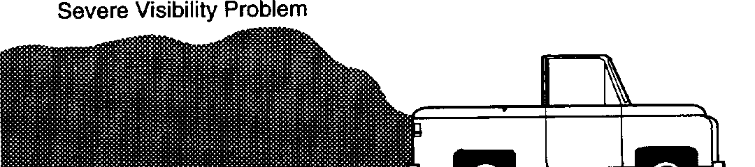
disintegrate because of loosening surface material (3) At security level H, normal traffic pro-or weak spots in the underlying soils.
duces a very thick cloud that severely obstructs
b. Severity levels. The levels of severity for visibility and causes traffic to slow down signifi-potholes are based on both the diameter and the
cantly or stop.
depth of the pothole according to table B-l below: Table B-1. Pothole severity levels
Average diameter
Less than
More than
1 foot
l-2 feet
2-3 feet
3 feet1
Maximum depth
(0.3 meter)
(0.3-0.6 meter)
(0.6-1 meter)
(1 meter)
1/2-2 inches (1.5-5 cm)
L
L
M
M
2-4 inches (5-10 cm)
L
M
H
H
4+ inches (10+ cm)
M
H
H
H
1If the pothole is over 3 feet (1 meter) in diameter, the area should be determined in square feet (square meters) and divided by 7 to find the equivalent number of potholes.
c. How to measure. Potholes are measured by and 240 square feet (23 square meters) with
counting the number that are low, medium, and
medium severity.
high severity in a sample unit and recording them
separately by severity level. For example, there
B-8. Distress 87-loose aggregate
may be 14 potholes of medium severity and 8
a. Description. The wear and tear of traffic on potholes of low severity.
unsurfaced roads will eventually loosen the larger aggregate particles from the soil binder. This leads B-7. Distress 86-Ruts
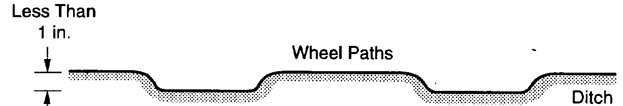
to loose aggregate particles on the road surface or a. Description. A rut is a surface depression in shoulder. Traffic moves loose aggregate particles
the wheel path that is parallel to the road center-away from the normal road wheel path and forms
line. Ruts are caused by a permanent deformation
berms in the center or along the shoulder (the
in any of the road layers or subgrade. They result less-traveled areas).
from repeated vehicle passes, especially when the
b. Severity levels.
road is soft. Significant rutting can destroy a road.
(1) At security level L, loose aggregate on the
b. Severity levels.
road surface, or a berm of aggregate (less than 2
(1) At security level L, ruts are less than 1
inches [5 centimeters] deep) on the shoulder or
inch (2.5 centimeters) deep.
less-traveled area.
(2) At security level M, ruts are between 1
(2) At security level M, moderate aggregate
and 3 inches (2.5 to 7.5 centimeters) deep.
berm (between 2 and 4 inches 15 and 10 centime-
(3) At security level H, ruts are deeper than 3
ters] deep) on the shoulder or less-traveled area. A inches (7.5 centimeters).
large amount of fine soil particles is usually found c. How to measure. Ruts are measured in square on the roadway surface.
feet (square meters) of surface area per sample
(3) At security level H, large aggregate berm
unit. For example, a sample unit may have 75
(greater than 4 inches [10 centimeters] deep) on
square feet (7 square meters) with high severity
the shoulder or less-traveled area.
B-4


Figure B-5. Severity Levels of corrugations (English and metric units).
c. How to measure. Loose aggregate is measured long has three berms of medium-severity loose
in linear feet parallel to the centerline in a sample aggregate-one on each side and one down the
unit. Each berm is measured separately. For ex-
middle-then the measurement would be 300 feet
ample, if a sample unit that is 100 feet (30 meters) (90 meters) at medium severity.
B-5


TM 5-626
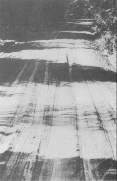
Figure B-6. Medium severity example of corrugations.
See-through
LOW SEVERITY
Visibility Moderately Obstructed
MEDIUM SEVERITY
Figure B-7. Dust severity levels (English or metric units) B-6
TM 5-626
Figure B-8. High severity example of dust.
B-7


TM 5-626
LOW SEVERITY
MEDIUM SEVERITY
HIGH SEVERlTY
LOW SEVERITY
MEDIUM SEVERITY
HIGH SEVERITY
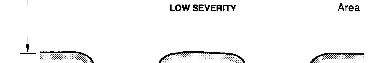
Figure B-9. Severity levels of potholes (English and metric units) B-8
TM 5-626
Figure B-10. High severity example of potholes.
B-9


TM 5-626
Figure B-11. Severity levels of ruts (English and metric units).
B-10
T M 5 - 6 2 6
Figure B-12. Low severity example of ruts.
B-11

Reads:
192
Pages:
58
Published:
Feb 2024
Unlock the treasure trove of knowledge with '500 Trivia Questions and Answers for Smart Kids'! This captivating book is designed to ignite the curiosity of yo...
Formats: PDF, Epub, Kindle, TXT

Reads:
633
Pages:
61
Published:
Feb 2024
"Try Not to Laugh! 1000 Hilarious Jokes for All Ages." is packed with rib-tickling humor and endless entertainment, this uproarious collection is guaranteed t...
Formats: PDF, Epub, Kindle, TXT

Reads:
27
Pages:
139
Published:
Mar 2023
This 11th volume “A Tribute To….” of the Sci-Fi Film Fiesta series is dedicated to the actors, directors, producers, special effects artists, writers and othe...
Formats: PDF, Epub, Kindle

Reads:
11
Pages:
48
Published:
Feb 2023
The SCI-FI FILM FIESTA eBook series is intended as a salute to the pioneering work of science fiction film makers. May future generations have the privilege o...
Formats: PDF, Epub, Kindle, TXT