CHAPTER VI
TO THE INDIES EASTWARD—PRINCE HENRY AND VASCO DA GAMA
Up to the fifteenth century the inhabitants of the Iberian Peninsula were chiefly occupied in slowly moving back the tide of Mohammedan conquest, which had spread nearly throughout the country from 711 onwards. The last sigh of the Moor in Spain was to be uttered in 1492—an epoch-making year, both in history and in geography. But Portugal, the western side of the peninsula, had got rid of her Moors at a much earlier date—more that 200 years before—though she found it difficult to preserve her independence from the neighbouring kingdom of Castile. The attempt of King Juan of Castile to conquer the country was repelled by João, a natural son of the preceding king of Portugal, and in 1385 he became king, and freed Portugal from any danger on the side of Castile by his victory at Aljubarrota. He married Philippa, daughter of John of Gaunt; and his third son, Henry, was destined to be the means of revolutionising men's views of the inhabited globe. He first showed his mettle in the capture of Ceuta, opposite Gibraltar, at the time of the battle of Agincourt, 1415, and by this means he first planted the Portuguese banner on the Moorish coast. This contact with the Moors may possibly have first suggested to Prince Henry the idea of planting similar factory-fortresses among the Mussulmans of India; but, whatever the cause, he began, from about the year 1418, to devote all his thoughts and attention to the possibility of reaching India otherwise than through the known routes, and for that purpose established himself on the rocky promontory of Sagres, almost the most western spot on the continent of Europe.
Here he established an observatory, and a seminary for the training of theoretical and practical navigators. He summoned thither astronomers and cartographers and skilled seamen, while he caused stouter and larger vessels to be built for the express purpose of exploration. He perfected the astrolabe (the clumsy predecessor of the modern sextant) by which the latitude could be with some accuracy determined; and he equipped all his ships with the compass, by which their steering was entirely determined. He brought from Majorca (which, as we have seen, was the centre of practical map-making in the fourteenth century) one Mestre Jacme, "a man very skilful in the art of navigation, and in the making of maps and instruments." With his aid, and doubtless that of others, he set himself to study the problem of the possibility of a sea voyage to India round the coast of Africa.
PROGRESS OF PORTUGUESE DISCOVERY
We have seen that Ptolemy, with true scientific caution, had left undefined the extent of Africa to the south; but Eratosthenes and many of the Roman geographers, even after Ptolemy, were not content with this agnosticism, but boldly assumed that the coast of Africa made a semicircular sweep from the right horn of Africa, just south of the Red Sea, with which they were acquainted, round to the north- western shore, near what we now term Morocco. If this were the fact, the voyage by the ocean along this sweep of shore would be even shorter than the voyage through the Mediterranean and Red Seas, while of course there would be no need for disembarking at the Isthmus of Suez. The writers who thus curtailed Africa of its true proportions assumed another continent south of it, which, however, was in the torrid zone, and completely uninhabitable.
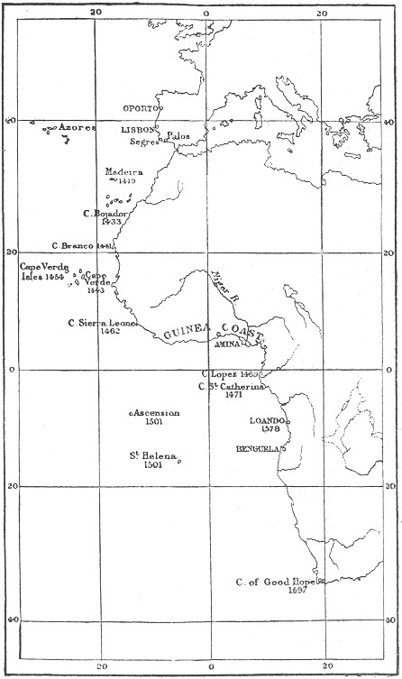
Now the north-west coast of Africa was known in Prince Henry's days as far as Cape Bojador. It would appear that Norman sailors had already advanced beyond Cape Non, or Nun, which was so called because it was supposed that nothing existed beyond it. Consequently the problems that Prince Henry had to solve were whether the coast of Africa trended sharply to the east after Cape Bojador, and whether the ideas of the ancients about the uninhabitability of the torrid zone were justified by fact. He attempted to solve these problems by sending out, year after year, expeditions down the north- west coast of Africa, each of which penetrated farther than its predecessor. Almost at the beginning he was rewarded by the discovery, or re-discovery, of Madeira in 1420, by João Gonsalvez Zarco, one of the squires of his household. For some time he was content with occupying this and the neighbouring island of Porto Santo, which, however, was ruined by the rabbits let loose upon it. On Madeira vines from Burgundy were planted, and to this day form the chief industry of the island. In 1435 Cape Bojador was passed, and in 1441 Cape Branco discovered. Two years later Cape Verde was reached and passed by Nuno Tristão, and for the first time there were signs that the African coast trended eastward. By this time Prince Henry's men had become familiar with the natives along the shore and no less than one thousand of them had been brought back and distributed among the Portuguese nobles as pages and attendants. In 1455 a Venetian, named Alvez Cadamosto, undertook a voyage still farther south for purposes of trade, the Prince supplying the capital, and covenanting for half profits on results. They reached the mouth of the Gambia, but found the natives hostile. Here for the first time European navigators lost sight of the pole-star and saw the brilliant constellation of the Southern Cross. The last discovery made during Prince Henry's life was that of the Cape Verde Islands, by one of his captains, Diogo Gomez, in 1460—the very year of his death. As the successive discoveries were made, they were jotted down by the Prince's cartographers on portulanos, and just before his death the King of Portugal sent to a Venetian monk, Fra Mauro, details of all discoveries up to that time, to be recorded on a mappa mundi, a copy of which still exists (p. 77).
The impulse thus given by Prince Henry's patient investigation of the African coast continued long after his death. In 1471 Fernando de Poo discovered the island which now bears his name, while in the same year Pedro d'Escobar crossed the equator. Wherever the Portuguese investigators landed they left marks of their presence, at first by erecting crosses, then by carving on trees Prince Henry's motto, "Talent de bien faire," and finally they adopted the method of erecting stone pillars, surmounted by a cross, and inscribed with the king's arms and name. These pillars were called padraos. In 1484, Diego Cam, a knight of the king's household, set up one of these pillars at the mouth of a large river, which he therefore called the Rio do Padrao; it was called by the natives the Zaire, and is now known as the River Congo. Diego Cam was, on this expedition, accompanied by Martin Behaim of Nürnberg, whose globe is celebrated in geographical history as the last record of the older views (p. 115).
Meanwhile, from one of the envoys of the native kings who visited the Portuguese Court, information was received that far to the east of the countries hitherto discovered there was a great Christian king. This brought to mind the mediæval tradition of Prester John, and accordingly the Portuguese determined to make a double attempt, both by sea and by land, to reach this monarch. By sea the king sent two vessels under the command of Bartholomew Diaz, while by land he despatched, in the following year, two men acquainted with Arabic, Pedro di Covilham and Affonso de Payba. Covilham reached Aden, and there took ship for Calicut, being the first Portuguese to sail the Indian Ocean. He then returned to Sofala, and obtained news of the Island of the Moon, now known as Madagascar. With this information he returned to Cairo, where he found ambassadors from João, two Jews, Abraham of Beja and Joseph of Lamejo. These he sent back with the information that ships that sailed down the coast of Guinea would surely reach the end of Africa, and when they arrived in the Eastern Ocean they should ask for Sofala and the Island of the Moon. Meanwhile Covilham returned to the Red Sea, and made his way into Abyssinia, where he married and settled down, transmitting from time to time information to Portugal which gave Europeans their first notions of Abyssinia.
The voyage by land in search of Prester John had thus been completely successful, while, at the same time, information had been obtained giving certain hopes of the voyage by sea. This had, in its way, been almost as successful, for Diaz had rounded the cape now known as the Cape of Good Hope, but to which he proposed giving the title of Cabo Tormentoso, or "Stormy Cape." King João, however, recognising that Diaz's voyage had put the seal upon the expectations with which Prince Henry had, seventy years before, started his series of explorations, gave it the more auspicious name by which it is now known.
For some reason which has not been adequately explained, no further attempt was made for nearly ten years to carry out the final consummation of Prince Henry's plan by sending out another expedition. In the meantime, as we shall see, Columbus had left Portugal, after a mean attempt had been made by the king to carry out his novel plan of reaching India without his aid; and, as a just result, the discovery of a western voyage to the Indies (as it was then thought) had been successfully accomplished by Columbus, in the service of the Catholic monarchs of Spain, in 1492. This would naturally give pause to any attempt at reaching India by the more cumbersome route of coasting along Africa, which had turned out to be a longer process than Prince Henry had thought. Three years after Columbus's discovery King João died, and his son and successor Emmanuel did not take up the traditional Portuguese method of reaching India till the third year of his reign.
By this time it had become clear, from Columbus's second voyage, that there were more difficulties in the way of reaching the Indies by his method than had been thought; and the year after his return from his second voyage in 1496, King Emmanuel determined on once more taking up the older method. He commissioned Vasco da Gama, a gentleman of his court, to attempt the eastward route to India with three vessels, carrying in all about sixty men. Already by this time Columbus's bold venture into the unknown seas had encouraged similar boldness in others, and instead of coasting down the whole extent of the western coast of Africa, Da Gama steered direct for Cape Verde Islands, and thence out into the ocean, till he reached the Bay of St. Helena, a little to the north of the Cape of Good Hope.
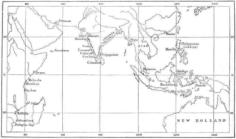
For a time he was baffled in his attempt to round the Cape by the strong south-easterly winds, which blow there continually during the summer season; but at last he commenced coasting along the eastern shores of Africa, and at every suitable spot he landed some of his sailors to make inquiries about Covilham and the court of Prester John. But in every case he found the ports inhabited by fanatical Moors, who, as soon as they discovered that their visitors were Christians, attempted to destroy them, and refused to supply them with pilots for the further voyage to India. This happened at Mozambique, at Quiloa, and at Mombasa, and it was not till he arrived at Melinda that he was enabled to obtain provisions and a pilot, Malemo Cana, an Indian of Guzerat, who was quite familiar with the voyage to Calicut. Under his guidance Gama's fleet went from Melinda to Calicut in twenty-three days. Here the Zamorin, or sea-king, displayed the same antipathy to his Christian visitors. The Mohammedan traders of the place recognised at once the dangerous rivalry which the visit of the Portuguese implied, with their monopoly of the Eastern trade, and represented Gama and his followers as merely pirates. Vasco, however, by his firm behaviour, managed to evade the machinations of his trade rivals, and induced the Zamorin to regard favourably an alliance with the Portuguese king. Contenting himself with this result, he embarked again, and after visiting Melinda, the only friendly spot he had found on the east coast of Africa, he returned to Lisbon in September 1499, having spent no less than two years on the voyage. King Emmanuel received him with great favour, and appointed him Admiral of the Indies.
The significance of Vasco da Gama's voyage was at once seen by the persons whose trade monopoly it threatened—the Venetians, and the Sultan of Egypt. Priuli, the Venetian chronicler, reports: "When this news reached Venice the whole city felt it greatly, and remained stupefied, and the wisest held it as the worst news that had ever arrived"—as indeed they might, for it prophesied the downfall of the Venetian Empire. The Sultan of Egypt was equally moved, for the greatest source of his riches was derived from the duty of five per cent. which he levied on all merchandise entering his dominions, and ten per cent. upon all goods exported from them. Hitherto there had been all manner of bickerings between Venice and Egypt, but this common danger brought them together. The Sultan represented to Venice the need of common action in order to drive away the new commerce; but Egypt was without a navy, and had indeed no wood suitable for shipbuilding. The Venetians took the trouble to transmit wood to Cairo, which was then carried by camels to Suez, where a small fleet was prepared to attack the Portuguese on their next visit to the Indian Ocean.
The Portuguese had in the meantime followed up Vasco da Gama's voyage with another attempt, which was, in its way, even more important. In 1500 the king sent no less than thirteen ships under the command of Pedro Alvarez Cabral, with Franciscans to convert, and twelve hundred fighting men to overawe, the Moslems of the Indian Ocean. He determined on steering even a more westerly course than Vasco da Gama, and when he arrived in 17° south of the line, he discovered land which he took possession of in the name of Portugal, and named Santa Cruz. The actual cross which he erected on this occasion is still preserved in Brazil, for Cabral had touched upon the land now known by that name. It is true that one of Columbus's companions, Pinzon, had already touched upon the coast of Brazil before Cabral, but it is evident from his experience that, even apart from Columbus, the Portuguese would have discovered the New World sooner or later. It is, however, to be observed that in stating this, as all historians do, they leave out of account the fact that, but for Columbus, sailors would still have continued the old course of coasting along the shore, by which they would never have left the Old World. Cabral lost several of his ships and many of his men, and, though he brought home a rich cargo, was not regarded as successful, and Vasco da Gama was again sent out with a large fleet in 1502, with which he conquered the Zamorin of Calicut and obtained rich treasures. In subsidiary voyages the Portuguese navigators discovered the islands of St. Helena, Ascension, the Seychelles, Socotra, Tristan da Cunha, the Maldives, and Madagascar.
Meanwhile King Emmanuel was adopting the Venetian method of colonisation, which consisted in sending a Vice-Doge to each of its colonies for a term of two years, during which his duty was to encourage trade and to collect tribute. In a similar way, Emmanuel appointed a Viceroy for his Eastern trade, and in 1505 Almeida had settled in Ceylon, with a view to monopolising the cinnamon trade of that place.
PORTUGUESE INDIES
But the greatest of the Portuguese viceroys was Affonso de Albuquerque, who captured the important post of Goa, on the mainland of India, which still belongs to Portugal, and the port of Ormuz, which, we have seen, was one of the centres of the Eastern trade. Even more important was the capture of the Moluccas, or Spice Islands, which were discovered in 1511, after the Portuguese had seized Malacca. By 1521 the Portuguese had full possession of the Spice Islands, and thus held the trade of condiments entirely in their own hands. The result was seen soon in the rise of prices in the European markets. Whereas at the end of the fifteenth century pepper, for instance, was about 17s. a pound, from 1521 and onwards its average price grew to be 25s., and so with almost all the ingredients by which food could be made more tasty. One of the circumstances, however, which threw the monopoly into the hands of the Portuguese was the seizure of Egypt in 1521 by the Turks under Selim I., which would naturally derange the course of trade from its old route through Alexandria. From the Moluccas easy access was found to China, and ultimately to Japan, so that the Portuguese for a time held in their hands the whole of the Eastern trade, on which Europe depended for most of its luxuries.
As we shall see, the Portuguese only won by a neck—if we may use a sporting expression—in the race for the possession of the Spice Islands. In the very year they obtained possession of them, Magellan, on his way round the world, had reached the Philippines, within a few hundred miles of them, and his ship, the Victoria, actually sailed through them that year. In fact, 1521 is a critical year in the discovery of the world, for both the Spanish and Portuguese (the two nations who had attempted to reach the Indies eastward and westward) arrived at the goal of their desires, the Spice Islands, in that same year, while the closure of Egypt to commerce occurred opportunely to divert the trade into the hands of the Portuguese. Finally, the year 1521 was signalised by the death of King Emmanuel of Portugal, under whose auspices the work of Prince Henry the Navigator was completed.
It must here be observed that we are again anticipating matters. As soon as the discovery of the New World was announced, the Pope was appealed to, to determine the relative shares of Spain and Portugal in the discoveries which would clearly follow upon Columbus's voyage. By his Bull, dated 4th May 1493, Alexander VI. granted all discoveries to the west to Spain, leaving it to be understood that all to the east belonged to Portugal. The line of demarcation was an imaginary one drawn from pole to pole, and passing one hundred leagues west of the Azores and Cape Verde Islands, which were supposed, in the inaccurate geography of the time, to be in the same meridian. In the following year the Portuguese monarch applied for a revision of the raya, as this would keep him out of all discovered in the New World altogether; and the line of demarcation was then shifted 270 leagues westward, or altogether 1110 miles west of the Cape Verdes. By a curious coincidence, within six years Cabral had discovered Brazil, which fell within the angle thus cut off by the raya from South America. Or was it entirely a coincidence? May not Cabral have been directed to take this unusually westward course in order to ascertain if any land fell within the Portuguese claims? When, however, the Spice Islands were discovered, it remained to be discussed whether the line of demarcation, when continued on the other side of the globe, brought them within the Spanish or Portuguese "sphere of influence," as we should say nowadays. By a curious chance they happened to be very near the line, and, with the inaccurate maps of the period, a pretty subject of quarrel was afforded between the Portuguese and Spanish commissioners who met at Badajos to determine the question. This was left undecided by the Junta, but by a family compact, in 1529, Charles V. ceded to his brother-in-law, the King of Portugal, any rights he might have to the Moluccas, for the sum of 350,000 gold ducats, while he himself retained the Philippines, which have been Spanish ever since.
By this means the Indian Ocean became, for all trade purposes, a Portuguese lake throughout the sixteenth century, as will be seen from the preceding map, showing the trading stations of the Portuguese all along the shores of the ocean. But they only possessed their monopoly for fifty years, for in 1580 the Spanish and Portuguese crowns became united on the head of Philip II., and by the time Portugal recovered its independence, in 1640, serious rivals had arisen to compete with her and Spain for the monopoly of the Eastern trade.
[Authorities: Major, Prince Henry the Navigator, 1869; Beazeley, Prince Henry the Navigator, 1895; F. Hummerich, Vasco da Gama, 1896.]