CHAPTER XI
THE MAKING OF THE ROMAN ROAD
The Great Initiative: The Mark of the Roman Military Engineer: The Theory and Practice of the Straight Line: Modifications of the Straight Line: How it was Carried Out: The Method of Odds and Evens.
The making of the great Roman roads was the one great initiative in the story of English communications: it originated all that followed, and there was no new real development, no essentially new departure between the planning of that military scheme and the coming of the railway. It can only be compared to what the future may have to show if we find ourselves able to reform our roads as they should be reformed for the new conditions of modern travel, and even this change would not be anything like as great as the change made by the throwing of those great highways to stand for ever across a country which had hitherto been half barbarous.
The Roman Road had a structure and character of its own which it has retained to the present day, so that even where it was only the straightening and the strengthening of an old trackway upon which it was founded it would follow the mark of the Roman engineers throughout all that remained of its course. It was essentially a piece of building, and in this the Roman Road differed from every other form of communication before the modern railways. It had to be of this kind on account of two things which the Roman military engineers particularly desired to serve, both of them connected with the military character of the west. First, they wanted a platform, raised, as a rule, above the surrounding country, so that troops passing along it should be the less liable to attack: so that a view could be had from it over the immediate surroundings, which were cleared: and so that any sudden stroke against a marching column could be checked. The raising of the way had other objects, of course—it kept the surface dry, for instance—but the main object was that of security upon the march, and the same object was one of the reasons for making the roads as a rule in straight lengths or limbs, sometimes two, three, or even four days’ march in extent. A road was planned without windings, so as to be safer from ambush and surprise, and where it had coupled to its straightness its elevation above the surrounding country the chance of ambush or surprise was almost eliminated.
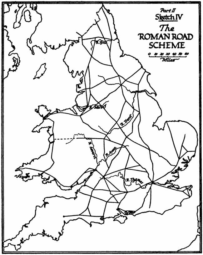
Part II, Sketch IV, The ROMAN ROAD SCHEME
But the habit the Roman military engineers had of driving their roads in these great straight limbs, which are still so clearly marked, served many other purposes besides this military one of which I speak. It has been condemned as a waste of effort, for it is clear that a winding road, avoiding steep gradients and turning difficulties of marsh or wood, requires less effort to construct, mile for mile, than an artificially straight one; and that even when you have allowed for the extra length of a winding road, the formula of least effort will never give you a long straight. But your straight road has the great advantage of rapid planning.
The Roman engineers, especially in the north—that is, in Belgium, Gaul, and in Britain—were working under campaign conditions, or in countries but recently occupied. They were under an imperative necessity of providing good communications as quickly as possible, and for that object the straight road was obviously the best. Once you had determined the two points which you had to join, you established a track between them and carried it over all but the worst obstacles, taking all but the worst gradients. If you met marsh, you built a causeway; whenever you came to a river crossing, you threw your bridge; when you came to a sharp, narrow ridge you made a cutting. All that meant labour, but as in any case you were intending to make a great built, constructed, raised structure along the whole trajectory the extra labour involved in a straight trace was not proportionally as heavy as it would be for one of our ephemeral modern roads. In other words, the Roman engineers set out upon a plan necessarily expensive. They set out to make a great public monument, as it were; and the extra expense of its straightness did not weigh in the bill.
A modification of this tendency to straight lines is found proceeding from three causes. First, where and when an established track already existed and the Roman work was only required to harden and strengthen it. Even there the Roman engineers would straighten portions which were too winding to fit in their scheme. But, apparently, where the track was fully established they tolerated a good many curves, especially if their work came some time after the conquest, when the land was settled.
The second modification of the plan is to be found in hilly countries. In the mountains or very hilly regions the Roman engineers of necessity gave up the straight line, and as these regions were also the districts where on the heights large garrisons were least necessary they were the better able to abandon their general military plan.
If you look at a detailed map of the Roman road system in Gaul or Britain you will see how the moment it comes to a broken district the straight lines are replaced by a waving trace such as you would have in a modern English road. For instance, beyond the Fosse in Dorsetshire and Devon the Roman coast road is as winding as any modern road can be. The same is true of the crossings of the Apennines, and, of course, of the crossings of the Alps and the Pyrenees. It seems to be equally true of the Ardennes gorges, but the trace here is often so much obliterated that it is difficult to say exactly how the Romans dealt with that mixed problem of wood and ravine.
The third modification was that of gradient. The Roman Road would take a very steep gradient indeed; but there was a limit, and when the slope was too steep the road diverged or zig-zagged, or took a combe in a great curve, or swept round the base of a hill. We have examples of all these points upon the map of England, the best of which, I think, are the great sweep of the Stane Street on Bignor Hill in Sussex and the great loop round Down Barn, north of Andover, on the road from Winchester to Glo’ster.
The greatest ingenuity was shown by the planners of the Roman roads in the choice of trace. Granted that you were to make a trajectory of many days’ march in large straight limbs, each limb had to be thought out very carefully, straight though it was, to yield something like a minimum of effort. You had to make your turning-points, or hinges, in the system at places where the straight lines joining them would cross water or hilly country to the best advantage, and it is astonishing with what skill these terminal points of the straight limbs were chosen. For instance, that one road of them all which has been most certainly of purely military use and designed to join Chichester with London (all of which I have worked out some years ago and on which I have written a monograph),[2] has its first bend from Chichester, just after the end of the first day’s march at the crossing of the Arun on Burgh Hill. The angle of the bend is one of seventeen degrees, the direction is north by twenty-two degrees east. Now, this direction of the two limbs which join at Burgh Hill exactly secures two things essential to the minimum of effort. One plain straight from Chichester to Leith Hill would have involved heavy effort in gradients and water. This plan of two limbs meeting at the Arun crossing gives every advantage:
(1) It makes the road cross the intervening range of the downs just where, by a slight curve, a reasonable gradient can be used;
(2) It makes it cross water and marsh at the narrowest point between Hardham and Pulborough, and at the same time just avoids the double water crossing of the Arun and the Rother. It is true that there is here something of a coincidence, but it was plan and survey which discovered that coincidence.
How were these great straight limbs plotted out? That is a question which has been fully debated but not yet settled. Where two ends of a trajectory were in sight one from the other the matter was simple enough; but what was the method used when the straight line exceeded the horizon: when it was carried on, for instance, for more than thirty miles, as is the case over and over again in the great north-eastern road from Paris to Cologne, and in the road from Amiens to Boulogne? What was the method when, even for lesser distances, one end of the trajectory could not be seen from the other on account of intervening hills, or where in flat land forests were sufficient to impede the view?
One theory has been that of smoke signals, a method which has been found of use, I believe, in barbarous countries in our own day. We must, I think, certainly reject it in such a climate as ours. Such signals could only here be used upon a few days in the year, specially picked, and the Roman engineers would not have depended upon the caprice of the weather. There has also been suggested (I adopted that suggestion myself in the monograph of which I have just spoken) the use of high movable platforms, but I now think that this also should be rejected on account of its clumsiness, and of the fact that in an uncleared country it would often be quite impractical. The most probable method was suggested to me by a correspondent some years ago, based upon his own experience in the planning of roads in new countries. It is the method of odds and evens, and requires some description with the aid of a simple plan.
Suppose that you have to construct a straight line from A to B, A and B not being visible one from the other, and the distance between them being considerable. If you have plenty of men with which to work (and the Roman military commanders did not lack these), you will proceed as follows: You send out your men from either end, in two chains as it were, each individual easily in sight of his next neighbour, but not nearer to him than is necessary for the observation of signals. These chains of men are either directed from the two ends of the line, or, if you can work only from one end, you send them out from that end, instructing the head of the chain when he comes in sight of the other end to work towards it and establish himself there. At the end of the process, whether you have been working with two lines approaching each other from either end and joining hands in the middle, or from one end only, you will end up with a line which will certainly not be straight—on the contrary, very irregular—but which will at least join your two goals. Probably, if you had been working from both ends, A and B, you would have something like sketch VI; while if you be working from one end only—A—the head of your column would probably be widely out at the conclusion of your experiment. Your column would have to double back sharply on to its goal when at last it was caught sight of, and you will have some such trace as on sketch V.
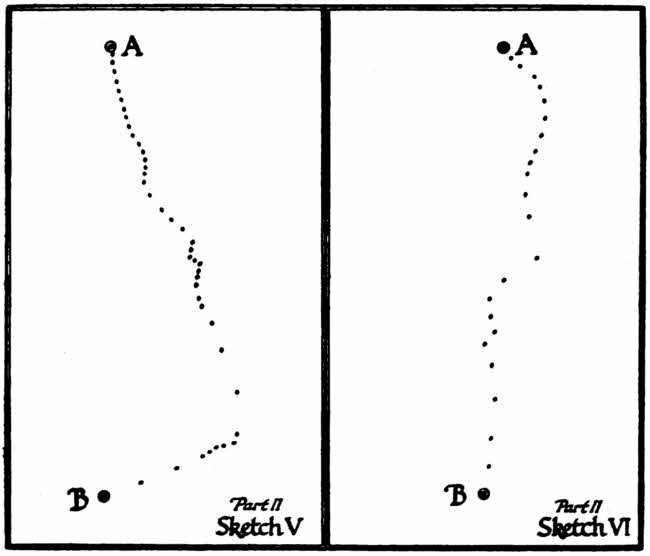
Part II, Sketch V Part II, Sketch VI
At any rate, having established this rough winding line, you next make the men number themselves as a line does when it is dressing, by odds and evens, or by ones and twos, so that the first, third, fifth, seventh man, etc., counting from one end make one lot, or all the ones make one lot, if you are going by ones and twos—and the second, fourth, sixth, eighth man, and so on, make another lot. You bid one of these sets—say the odds—to face towards one goal—say B—and the other set to face towards the other goal—A. Lastly, you bid them space themselves out so that any individual of one set can at least clearly see his fellow in the same set along the direction to which he faces, and the man of the other set in between. For instance, No. 39, looking south towards B, must be able to see No. 37, who is facing the same way as he is, and must at the same time be able to see No. 38, who is facing towards him; similarly, No. 38 must be able to see No. 40 clearly, and No. 39 in between. It is clear that in thick, “blind” country (as, for instance, in woods or in tumbled land) your men will have to stand fairly close together. But in open country they can be at considerable distances—up to half a mile or more; so long as every unit can see the next unit of the same set clearly, and have his signals received by the unit of the other set in between, the conditions are satisfied. Your line being thus instructed (and, as anyone may discover in practice, it is not a very long business once the first rough chain has been established), the numbers of each set signal to the intervening numbers of the other set alternatively to move to right or left until a straight line is locally established.
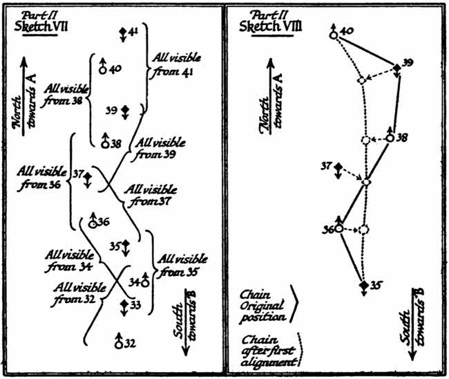
Part II, Sketch VII Part II, Sketch VIII
For instance, in sketch VII you begin with the “evens,” looking northward. No. 38, looking north towards No. 40, sees that No. 39 (who faces him, looking south) is somewhat too much to the east and does not stand properly between him and No. 40. He signals to No. 39 to move westward as along the dots until No. 39 is at a new position, shown by the dotted circle exactly between No. 38 and No. 40. Next, No. 36 signals to No. 37, who is too much to the west, until No. 37 is exactly between himself and No. 38. When this has been done all along the line by the evens the order is given to the odds to repeat the process from their new positions. No. 39, looking southward from his new position at the dotted circle, sees that No. 38 is too far to the east to be in perfect alignment with No. 39’s next odd neighbour No. 37, at whom he is looking, southward. No. 39 signals, therefore, to No. 38, who is looking northward, to move westward, and No. 38 does so until the signal stops him, when he is just in line between the new positions of No. 39 and No. 37.
It will be evident that after this first stage of the process the original irregular line between A and B will have been much straightened. You have but to repeat the manœuvre half a dozen or a dozen times to get the whole body of men into a strictly straight line between the two extremities many miles apart, and that although those in the middle cannot see either extreme and neither extremity can see the other. In theory this method can be used for an indefinite extent of country. In practice it seems to have been used (if it were indeed that upon which the Roman engineers relied) for spaces sometimes as great as a three days’ march, and quite often as great as one day’s march or more.
The scheme of Roman roads, following in the main these great straight limbs, covered the whole country, and was for the most part completed, we may presume, by the end of the second century.
It must not, of course, be imagined that these great military ways were the only means of communication in Roman times. Many historians have fallen into that grotesque error, with the result that history becomes meaningless to their readers. These great ways were only the main arteries, which were linked up in all the intervening spaces by a mass of local ways not specially constructed or engineered—most of them presumably aboriginal, and also maintained presumably by a local authority.